The Road Much Taken
The history and future of Loop 610

According to the Texas Department of Transportation, the West Loop Freeway (I-610) is the most congested freeway in the state of Texas and the Southwest Freeway (I-59, now also called I-69) is the third.
And the interchange at which they meet? It will not surprise Buzz readers to hear that it’s “the No. 1 worst choke point for the entire state of Texas.”
That’s what Bruce Bugg, Jr., the chairman of the Texas Transportation Commission, said at the November groundbreaking for the interchange’s $287 million, 5-year reconstruction.
One of the reasons for building the Loop in the first place was the need to reduce congestion, recognized as early as 1931, on city streets. Another reason was the military’s request for a clear route if it ever needed to deploy to protect the Houston Ship Channel, which is why the Loop in early planning documents is sometimes referred to as the Defense Loop. According to Houston Freeways, the definitive book of history by Erik Slotboom, a bond issue was approved for the Loop in 1941, just months before Pearl Harbor was attacked.
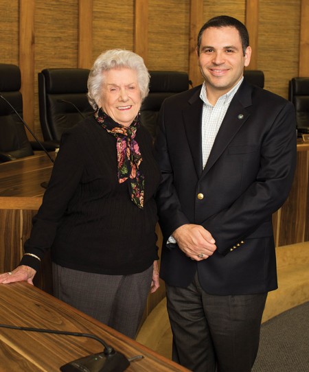
Betty Janicek, who turned 94 last month and was the mayor of Bellaire in 1991 and 1992, can remember when the first part of the Houston freeway system, the Gulf Freeway (I-45), was built in 1948-49. She and her husband used to pile their kids in the car on Sunday afternoons after church and drive on it just for fun. But she said, “Even before it was finished, it was clear that it was inadequate.”
Houston freeway planners couldn’t probably have visualized how much and how quickly the city would grow. According to Slotboom, in 1968, when the main lanes of the West Loop were opened, its peak traffic was 96,000 vehicles per day. In 1971, a year after the Galleria opened, it was just over 146,000. Today, according to TxDOT, the interchange being reconstructed handles about 500,000 vehicles per day routinely. And TxDOT is eyeing forecasts that the population of the Houston metropolitan area will more than double, from 6.6 million to 14.2 million, by 2050.
With this newest construction project, which has already started, TxDOT “will be touching every part of the interchange,” says Frank Leong, area engineer for the Houston district of TxDOT. The interchange is every way the two freeways connect with each other. There are eight of these connectors. All but one will be enlarged from one lane to two. The one ramp not enlarged – 59 southbound to 610 northbound – will still be reconstructed and improved. There’s just not enough space to widen this ramp to two lanes.
The bridge where 610 crosses over 59 will also be adjusted, to allow room for the new connectors, and it will be given shoulders for safety.
The busyness of Houston’s freeways is a sign of the city’s economic health. At the ground-breaking in November, held overlooking the interchange, traffic sounds, including a couple of blaring truck horns, were loud. But, pointed out John Breeding, president of Uptown Houston District, “What you hear is the very economy of Houston.”
Which isn’t to say that accommodating that traffic isn’t a problem.
In 2015, Texas Gov. Greg Abbott directed the Texas Transportation Commission to create an initiative, called Texas Clear Lanes, to focus on congestion relief in the state’s five largest metropolitan regions. The West Loop/Southwest interchange topped their list as the most congested.
And it was always known, since its inception (it opened in July 1962), that this interchange would be busy. When it was built, it was, Slotboom says, the first modern “four-stack,” an interchange where roads cross each other at four different levels, in the state of Texas.
It was also, more ominously, the first place in the U.S. where “crash attenuators,” crash cushions, also sometimes referred to as “cowboy cushions,” were used. These devices, such as plastic barrels filled with sand, are meant to disperse the energy of a crash and protect the people involved. These are placed, of course, where crashes are more likely to occur, such as the “gore points” on highways.
Incidentally, gore points are not named after blood and gore, but are the triangular slivers of land between a freeway and its ramps. The term comes from either the Old Norse word for “spear,” or from a dress-making term for the triangular pieces of cloth used to make certain styles of skirts.
“This interchange has been, frankly, dangerous for years and years,” says Bellaire Mayor Andrew Friedberg. “Many people have been involved in accidents there, including me.” The City of Bellaire fire and police departments respond daily to accidents there.
Building a freeway or even reconstructing part of it involves a lot of moving parts and a lot of different stakeholders. Betty Janicek can remember when the West Loop was planned in the 1950s. During the period when the freeway’s route was being decided, which lasted about two years “from the first whispers to the final announcement,” she says, “there was a lot of crying and carrying on and arm-waving.” Without a doubt, many people’s lives were uprooted. Close to 200 families in Bellaire were forced out of their homes. “I didn’t feel like they were chiseled when it came to how much they were paid for their property,” says Janicek, “but these people were living in the homes and in the community they had planned to live in all their lives.”
According to Slotboom, there were times – such as when the West Loop, which split Bellaire in two, was being planned – when it was almost always impossible for a local community to put a stop to a freeway it disagreed with. Slotboom has, in his archives, an article from the Bellaire Texan, a weekly newspaper, dated April 1956, reporting an exchange between a Bellaire resident and the county commissioner at a public meeting. “Then the freeway is a foregone conclusion. We’re here only to get our gripes off our chest,” said the resident, to which the commissioner replied, “That just about sums it up.”
On the other hand, according to Slotboom, once President Nixon signed the National Environmental Policy Act of 1969, it became almost impossible to build a freeway if the local community objected.

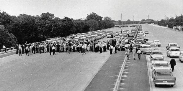
A CITY OF HIGHWAYS Houston's history is intertwined with its freeway system. Here, the first section of the Southwest Freeway opened on July 26, 1961.
In 1991, a widening of the West Loop between the Southwest and Katy freeways was proposed. It would have been major. The leading proposal was to make the West Loop, counting its feeder roads, 24 lanes across. This would have required the use of 3½ acres of Memorial Park. The proposal was strongly opposed – Slotboom described one TxDOT public meeting as becoming “more like an anti-freeway rally” – and was ultimately defeated.
A less drastic construction project, which did not add capacity but did make improvements, was done to the West Loop in the late ’90s, despite some opposition.
This time around is not as contentious. “TxDOT at the end of the day can do what it wants. It doesn’t need our permission,” says Bellaire Mayor Friedberg, “but we were very pleased that they worked with us.”
Bellaire asked for – and got – three modifications to the original design. The ramps were made significantly lower. “We’d prefer them not to tower over our community,” says Friedberg. Also, in the original plan, the Fournace exit was going to be permanently closed; now it will eventually reopen, though it is currently closed and will be for at least two years during construction.
Perhaps most importantly, the City of Bellaire struck a deal with TxDOT to improve the drainage capacity under 610. While technically TxDOT is only responsible for handling any extra drainage problems caused by one of its construction projects, it has agreed to a shared-funding deal where the City of Bellaire will pay $1 million of the $3 million cost to put in a 10-foot by 8-foot box culvert running from just south of Westpark to Glenmont, to help with flooding.
This project started in September with utility work around South Rice, Westpark and the 59 North and 610 South frontage roads. The 59 HOV entrance and exit ramps at Westpark have been closed for the duration of the project. The HOV can be entered and exited at Edloe. Next up, starting in the spring, will be the construction of sound walls, on 59 southbound from Sage to Chimney Rock and on the West Loop South in two places, from Lehigh to Glenmont and from Fournace to Elm. The first connector to be rebuilt will be 59 North to 610 South, beginning sometime in the late summer or fall.
The entire project is scheduled to take five to six years.
Meanwhile, the construction company, Williams Brothers, will be working seven-day workweeks, with closures planned at night and during weekends. And TxDOT will be using new “smart work zone” technology. This is movable signage, placed before where traffic will snarl, that will be connected to sensors monitoring traffic conditions to give drivers real-time information about road conditions. “It’s a key warning system about speed, congestion and back-ups that can let drivers know what’s going on over the next overpass,” says Darrell Borchardt, senior research engineer at the Houston office of the Texas A&M Transportation Institute.
“Yes, it’s going to be a pain in the elbow while it’s under construction,” says Betty Janicek, “but isn’t it going to be wonderful when it’s done?”
Want more buzz like this? Sign up for our Morning Buzz emails.
To leave a comment, please log in or create an account with The Buzz Magazines, Disqus, Facebook, or Twitter. Or you may post as a guest.


